
Project
A search and rescue department needs to compute a flight profile and camera pointing sequence to reconnoitre a given area without gaps in the coverage. Develop a model for generating the optimal search strategy for a remotely piloted (or pilotless) vehicle.
Strategy
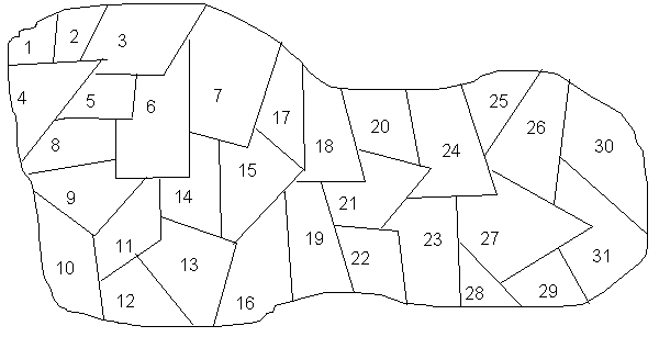
There may be various way to model this problem. However, the appraoch that we are using used the models we've learned during the class. We model this problem by broken it down into two subproblems. The searched area is divided into smaller areas and each area is numbered accordingly. Then it will be modelled as a set covering problem. The objective is to find which area the plane should be in order to cover the whole area. Then, we model it as a transportation problem and find the best route to travel across those optimal points.
Problems:
Limitation
There are some limitation to our model:
Avenues for Further Study
Related Sites...
The Role of Fuel-Optimal Flight Plans in Maintaining Regular Operations
NASA Success Story: Flight Planning
Design of Flight Control Systems by Optimal Control Methods
![]()
by
Breonda Carrigan, Cari McRae & Queenie Li